It was the warmest month since November 2018, the second warmest November in the record (just behind 2015), and makes it likely that in this record, 2020 will be warmer than 2016, and hence the warmest full year in the record. The mean to November is 0.873°C, vs 2016 0.857, so December only has to be moderately warm for that to happen - in fact 0.681°C would be enough. I see the betting odds on that event are only 42% - or course they are not based on TempLS.
|
Housekeeping note For the last six years I have made three global temperature postings every month - the NCEP results, then the TempLS results, and finally the comparison with GISS. But recently the GHCN data are posted so promptly that they are available almost as soon as NCEP. So I will in future merge the first two postings; no separate posting for NCEP. |
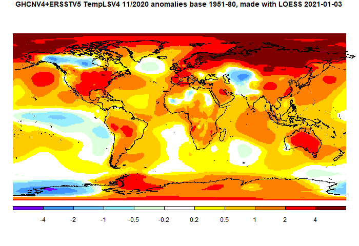
There was a cool region in N Canada, but warm in the USA. Mainly, it was very warm in the Arctic, with an adjacent very warm region right across Eurasia. Most of the rest of the land was warm, including Antarctica. There was a cool area in central Asia.
Here is the temperature map, using the LOESS-based map of anomalies.
 As always, the 3D globe map gives better detail.
This post is part of a series that has now run since 2011. The TempLS mesh data is reported here, and the recent history of monthly readings is here. Unadjusted GHCN is normally used, but if you click the TempLS button there, it will show data with adjusted, and also with different integration methods. There is an interactive graph using 1981-2010 base period here which you can use to show different periods, or compare with other indices. There is a general guide to TempLS here.
The reporting cycle starts with a report of the daily reanalysis index on about the 4th of the month. The next post is this, the TempLS report, usually about the 4th. Then when the GISS result comes out, usually about the 15th, I discuss it and compare with TempLS. The TempLS graph uses a spherical harmonics to the TempLS mesh residuals; the residuals are displayed more directly using a triangular grid in a better resolved WebGL plot here.
A list of earlier monthly reports of each series in date order is here:


GISS November data is out with the largest rise since 1930. Making it the warmest November ever, equaling the 2016 SON record and braking the 12 D-N 2016 record. Prediction of my model will follow if ready.
ReplyDeleteThanks Uli. It is a big new data point for the prediction. I'll write a post soon.
DeleteThanks Nick. I posted the prediction for 2020 and now for 2021 too.
Delete