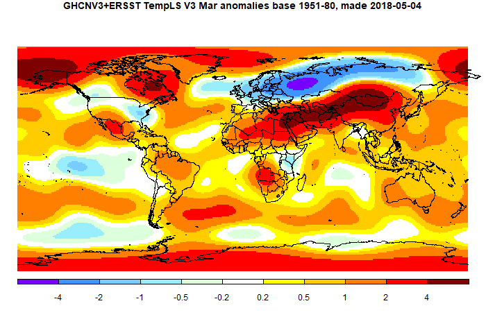
There were two major bands of weather, one cold, one warm. The warm belt spread from N China to the Sahara, being very warm from Mongolia to Egypt. The cold band went from N Siberia to Britain, being very cold in NW Russia. Both poles were moderately warm. For the Arctic, this is a big reduction since last month, so indices like NOAA and HADCRUT might rise more than GISS. TempLS grid, which also undercounts poles, rose 0.07°C.
Another noticeable pattern, similar to last month, was a band of SST warmth extending right around the 35-45° S latitudes.
Here is the temperature map. As always, there is a more detailed active sphere map here.

This post is part of a series that has now run for six years. The TempLS mesh data is reported here, and the recent history of monthly readings is here. Unadjusted GHCN is normally used, but if you click the TempLS button there, it will show data with adjusted, and also with different integration methods. There is an interactive graph using 1981-2010 base period here which you can use to show different periods, or compare with other indices. There is a general guide to TempLS here.
The reporting cycle starts with a report of the daily reanalysis index on about the 4th of the month. The next post is this, the TempLS report, usually about the 8th. Then when the GISS result comes out, usually about the 15th, I discuss it and compare with TempLS. The TempLS graph uses a spherical harmonics to the TempLS mesh residuals; the residuals are displayed more directly using a triangular grid in a better resolved WebGL plot here.
A list of earlier monthly reports of each series in date order is here:


I notice that the February value has gone up by almost 0.03 C since the February report. I think that late data from Sudan and the Canadian Arctic archipelago made the difference.
ReplyDeleteThus, it's likely that Gistemp for February also will be corrected up a few hundreths with the coming update. The effect of missing data in the high Canadian Arctic is very obvious in the Gistemp map. Also, the white spot over Sudan will likely be replaced by deep red.. See:
https://moyhu.blogspot.se/2018/03/giss-february-global-temperature.html#more
Olof,
DeleteYes, I have noticed that the last few months there is late upward creep. This month too an initial drop of about 0.05 turned into a rise when I posted. I have been collecting data on when the various countries and stations report, which I will post on soon. I don't know why the creep always seems to be upward.
If there is an upward creep, could it be that early reporting cool SST initially infills land, but later becomes replaced with warm "real" land data from late reporting countries?
DeleteOlof,
DeletePossibly, but I don't see why land anomalies should necessarily be warmer than SST. Maybe Greenland has been in recent months.
Lots of detail missing with respect to Tropical Instability Waves along the equator.
ReplyDeleteHave a feeling much of the variation will be deduced from satellite measurements that can pick up variations as small as this research "Earth's magnetic ocean tides mapped from space"