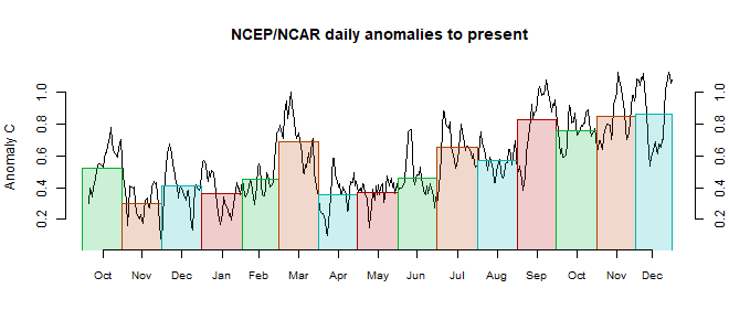
In the
Moyhu NCEP/NCAR index, the monthly reanalysis average declined from 0.337°C in August to 0.317°C in September, 2017. It was again a very varied month; it looked as if it would come out quite warm until a steep dip about the 23rd; that cool spell then lasted until the end of the month.
The main feature was cold in Antarctica, so again we can expect this to be strongly reflected in GISS and TempLS, and less in NOAA and HADCRUT. Elsewhere, cold in Central Russia, but warm in the west; fairly warm around the Arctic.


Warmest september on record for UAH. All this with neutral ENSO state and equatorial Pacific SST only a tad above average. Nonetheless, skeptics are trying to prove there was indeed an El Niño this Summer, explaining why it is so warm : "“We saw a big rise in sea surface temps in June and July. The atmosphere tends to respond two or three months later, so this is what you would expect. The atmosphere is still feeling this big heat anomaly, so this is the right time for the atmosphere to see this peak.”" from https://wattsupwiththat.com/2017/10/02/global-temperature-report-september-2017/ or " Richard M says:
ReplyDeleteOctober 2, 2017 at 8:09 AM
We had El Nino conditions for much of the first part of the 2017. This is the reason for the bump in temperatures in August and September as satellite temps always lag by about 3 months. Since this is equatorial it tends to affect both hemispheres equally.
That has now ended. October should see a drop. If La Nina conditions take hold (haven’t yet) then look for another change 3 months later." from http://www.drroyspencer.com/2017/10/uah-global-temperature-update-for-september-2017-0-54-deg-c/ Don't mind the ENSO state, it is due to the ENSO.
P.S. : And October could be quite warm also, but now Pacific is definitively cooling, even when couting with a 3-months lag... As someone suggested over at Roy Spencer blog, time for a 7th version of the UAH. The current one is running too warm now...
ReplyDeleteThe El Niño ended in May 2016. We have had ENSO neutral conditions since then. The cold tongue of cold water extending westward from Peru is being completely fenced in by warm water. In the last 7 days Niño 3.4 has warmed considerably. Winds have not been strong enough to push it westward, so the 2016 La Niña was a runt and the 2017/2018 La Niña, should it come to be, will also be a runt as the North Pacific is hot and getting hotter.
ReplyDeleteSorry, the was a La Niña in the last 5 months of 2016.
ReplyDelete"rose" from 0.337°C in August to 0.317°C in September?
ReplyDeleteI'm assuming that's just a simple mistake?
yes. It comes from adapting last month's text. Sorry - fixed.
Delete