Slightly O/T, but there has been a recent spike in February, according to the NCEP/NCAR index. It has now pulled back a bit.
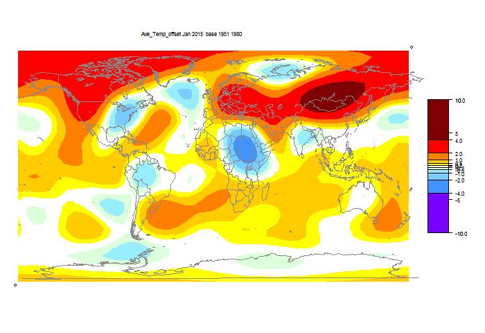
Here is the GISS map:

Warm in Western N America, esp NW, cold in East (a common pattern lately). Warm in NE Europe and Siberia.
Here is the TempLS grid map:

It shows similar features, with more warmth in Mongolia, and a cooler spot in Africa.
And here is the similar TempLS mesh plot:


Nick,
ReplyDeleteWhere you live looks very near the historical average. The frequent howls from my friends and relatives in the US Northeast confirm the TempLS maps... it s very cold this year, at least based on the memories of people 30 to 60 years old who live there.
Yes, we've had what people regard as a cool summer, though average historically (and very pleasant). And yes, I have relatives in NY who are sick of the winter.
DeleteHmm, the maps indicate an anomaly in the US N.E. of somewhere between -1 and -2 degrees, i.e. colder than average, though not hugely so. It strikes me the TempLS data somewhat undermine the claims of extreme cold from your friends and relatives. Maybe a more, er, skeptical, view of anecdotal evidence would be in order here, Stephen. For instance could their "howls" be occasioned more by heavy snow than low temperature? As I indicate further down this thread the severity of snowfall should definitely not be assumed to be a proxy for temperature
DeleteI'm not trying to belittle the hardship that people in this part of N. America are enduring. However, this blog is very much concerned with the rigorous assessment of data.
A friend of mine builds guitars in Canada, and it was -50F there the other night. They have had a miserable winter. It was 80F here in Ft. Worth yesterday, but just barely above freezing all day today. My hunch was January was going to go higher than December, but by more than it did. Still, February looks like a burner to me.
ReplyDeleteThe striking thing concerning East North America is the juxtaposition of cold land and very warm ocean, this latter fact apparently being overlooked by Steven F's relatives. This very durable pattern of warmth and cold has continued into February, hence the huge amount of snowfall. No wonder your relatives in NY are sick of their weather, Nick.
ReplyDeleteIn his latest post Robertscribbler shows a remarkable graphic from Nullschool showing SST anomalies of +11 degrees adjacent to the North Atlantic coast coinciding with the latest snowstorms over Boston. Unfortunately I am not yet sufficiently skilled with Nullschool to be able to generate this for myself.
Oh, I should have specified that I am using S.I units for temperature.
DeleteBill,
DeleteHere is the SST movie for the area, last 50 days. Shows SST, not land. Very strong Gulf Stream.
I might have known you would have these in among all your various data visualisations! That said the highly non-linear colour scale seems very strange.
DeleteOn another matter, I've just noticed that Australia is being hit simultaneously by two cyclones - one cat 4, the other cat 5. Fortunately, both seem to be away from major population centres, but I would guess flooding could be very serious. Is there any precedent for such a "double hit"?
Bill,
DeleteThe thing is, there is a lot of cyclone generating water close to Australia, whereas in US the hurricanes usually come from quite a long way away. It's reasonably common to have cyclones active in the Indian Ocean and Pacific at the same time, but they affect far separated areas. Lam is unusual in that it formed in the Gulf of Carpentaria, so Qld is being hit from both sides. But Marcia will affect more people.
This answers my question: 2 simultaneous major typhoons is a first for Australia.
Deletehttp://www.farmonline.com.au/news/agriculture/general/weather/twin-tcs-a-first-for-australia/2724244.aspx
Up to 285 km/s for Marcia. That's a major cat 5 storm!
Hi Nick, Thanks for a very interesting blog...
ReplyDeleteI noticed that the TempLS mesh index ticked up with 0.010 degrees. I believe it was Sudan that reported a bunch of data (long time no see) and that filled "the blue hole" in Africa a little bit.
Thanks,
DeleteYes, I thought the blue hole was a bit of an artefact due to missing readings. That artefact doesn't affect the mesh average, though, which is not SH based. But of course the extra warm readings will increase it, as you say.
I guessI am the only person to whom this is interesting, but I believe the 12 months ending on January 31, 2015 is the warmest 12 months in the GISS thermometer record. So the warmest year sort of took the big one 31 days later, just as the skeptics predicted! The anomaly for the 11 months ending January 31, 2015 is .701C. Looking at NCEP for February 2014, (.44C) this February appears to be well on the way to smashing .44C. It also looks to be in the range of Feb 1998, which is the record for Feb at .86C.
ReplyDeleteYes, the year to end Feb should be very high, since it drops the cold Feb of 2014.
DeleteI was wrong on the 11 months. It's .704545C:
Deletehttp://www.woodfortrees.org/data/gistemp/from:2014.16
So times eleven; plus .86C (i'm an optimist); divide by 12 = .71750C. Same thing happens in May and June, which looks to be at least ENSO neutral, and it has to be getting close to statistically significant warming.