The evidence is supposed to be this graph, taken from this paper: SEEING THE WOOD FROM THE TREES. KR Briff and TJ Osborn, Science, 1999
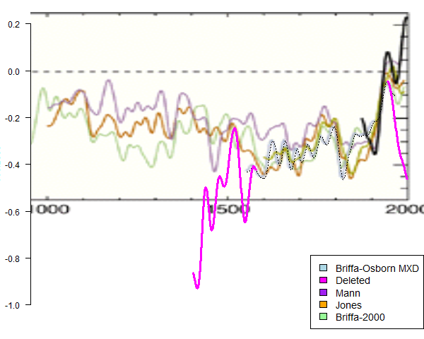
The pink bits have been helpfully added by Steve McIntyre, based on numbers he found in an XL file which had been apparently inadvertently attached to another paper's data archived at NOAA. It's undocumented there.
Well, it seemed clear to me that the available data is just getting low as we go back beyond 1550, and the wild swings are just the result of the growing noise, as you'd expect. And I haven't found anyone who seems to seriously think they reflect any kind of reality. So Briffa sensibly stopped at 1550 to avoid misleading the public. But no, it's apparently academic misconduct, another Yamal even. [ed.. But, but, wasn't that about actually proceeding with plots where data was running low? O, never mind, ethical violation etc].
So I belatedly saddled up and sallied forth to dispute at CA and tAV. I don't want to rehash that here, nor transfer the debate, which I'll continue there. In the course of it, there was argument about how much the data was actually reducing, and Steve McI pointed me to the archived list of sites at UEA. There isn't one for the Science paper but there is a list for the Nature paper that it references:
Briffa KR et al. (1998) Influence of volcanic eruptions on Northern Hemisphere summer temperature over the past 600 years. Nature 393, 450-455.
and a list for a subsequent paper
Briffa KR et al. (2001) Low-frequency temperature variations from a northern tree-ring-density network. J. Geophysical Research 106, 2929-2941.
From these, I could extract a graph for the rate at which the number of sites was reducing in the relevant period. I also made lists of the actual sites concerned.
The reason for plotting the JGR paper as well is that Steve M pushed the claim that the JGR paper had plotted down to 1400, while the Science paper stopped at 1550. They referenced different data sets, so I wanted to check if they perhaps had more data in the later paper. As you'll see, the answer is no, but they did claim in the second paper to have an improved method, which might well allow them to go further back in time.
Anyway, here is the plot of number of sites vs time, over all time.

As you can see, the number of sites is dropping rapidly before 1600, and is down to about 40 near 1550. Here is the expanded region between 1400 and 1600:

As you can see, the rate of decrease is quite sharp near 1550. There's no absolute rule on where you have to say that a plot has to be stopped. The noise rises relative to the signal in a continuous way, and I don't curently know how to quantify whether 40 sites is likely to be sufficient. But neither do the critics. What is clear is that the observed rapid changes observed in McIntyre's graph are closely associated with the steep reduction in data. In those circumstances, I would be very uncomfortable about presenting them as real. And I don't think referees would let me.
Here is a list of the first 61 sites from the 1998 Nature paper. I won't list the corresponding JGR sites, as it is very similar.
| "ID" | "Name" | "Abbr" | "Genus" | "Lon" | "Lat" | "Start" | "End" | |
| "276" | " 862A " | " Polar-Ural (historisch) " | " POU_LA " | " LASI " | 65.63 | 66.87 | 914 | 1990 |
| "253" | " 928A " | " Mangazeja (hist. + rez.) " | "MANGAZPC " | " PCOB " | 82.3 | 66.68 | 1246 | 1969 |
| "252" | " 928D " | " Mangazeja (historisch) " | "MANGAZLA " | " LASI " | 82.3 | 66.68 | 1307 | 1698 |
| "301" | " 913A " | " Zhaschiviersk " | "ZHASHIST " | " LASI " | 142.62 | 67.45 | 1311 | 1708 |
| "351" | " 1041A " | " Majakit river/village " | "MAJAKILA " | " LADA " | 151.95 | 61.28 | 1338 | 1994 |
| "278" | " 930A " | " Seimchan-river " | "SEIMCHLA " | " LADA " | 151.72 | 63.52 | 1362 | 1991 |
| "215" | " 745A " | " Sylvan Pass bei Cody " | " SYLVAN " | " PCEN " | -110.13 | 44.37 | 1388 | 1983 |
| "264" | " 1017A " | " Nuleger river " | "NULEGELA " | " LADA " | 127.43 | 71.22 | 1391 | 1990 |
| "174" | " 691A " | " Jasper " | " SUNW " | " PCEN " | -117 | 52.25 | 1400 | 1983 |
| "383" | " 9999Z " | " Tornetrask " | " TORNXX " | " PISY " | 19.5 | 68.3 | 1400 | 1980 |
| "206" | " 731A " | " Medicine Bow Peak " | " MEDI " | " PCEN " | -107.7 | 41.3 | 1401 | 1983 |
| "372" | " 992A " | " Qamdo " | " QAMDOFI " | " PCBA " | 96.95 | 31.08 | 1406 | 1994 |
| "337" | " 1014A " | " Bilibina,Mali Anuj river " | "BILIBILA " | " LADA " | 167.67 | 67.47 | 1432 | 1991 |
| "382" | " 1060A " | "Tschokurdach,Ochotingna r " | "TSCHOKLA " | " LADA " | 148.05 | 70.28 | 1434 | 1990 |
| "48" | " 630A " | " Sierra da Crispo " | " CRISPO " | " PILE " | 16.23 | 39.9 | 1441 | 1980 |
| "332" | " 1032A " | " Andryuschkine " | "ANDRYULA " | " LADA " | 145.77 | 69.28 | 1449 | 1991 |
| "268" | " 899A " | " Olenjok " | "OLENJOLA " | " LAGM " | 112.53 | 68.52 | 1450 | 1990 |
| "214" | " 686A " | " Snow Bowl, San.Fr. Peak " | " SNOW " | " PCEN " | -110.2 | 35.43 | 1453 | 1983 |
| "377" | " 1063B " | " Adycha river (flach) " | "ADYBOALA " | " LADA " | 137.25 | 65.8 | 1481 | 1991 |
| "304" | " 865A " | " Olenok-River " | "ZWANZGLA " | " LAGM " | 119.1 | 68.52 | 1482 | 1990 |
| "316" | " 540A " | " Lofoten, Loedingen " | " LOFOTN " | " PISY " | 16.03 | 68.48 | 1485 | 1978 |
| "333" | " 955A " | " Balshoia Anui " | "BALANULA " | " LADA " | 165.42 | 66.22 | 1492 | 1991 |
| "198" | " 692A " | " Highland Fire Outlook " | " HIGHL " | " PCEN " | -112.53 | 45.75 | 1496 | 1983 |
| "209" | " 733A " | " Powder River Pass " | " POWDER " | " PCEN " | -107.05 | 44.15 | 1496 | 1983 |
| "352" | " 981A " | " Omoloya river " | "OMOLOYLA " | " LADA " | 132.98 | 70.95 | 1496 | 1991 |
| "380" | " 1070A " | " Balygichan-river " | "BALYRILA " | " LADA " | 154.58 | 62.13 | 1497 | 1994 |
| "188" | " 762A " | " Barlow Pass, am Mt.Hood " | " BARLOW " | " PSME " | -121.65 | 45.32 | 1504 | 1983 |
| "200" | " 746A " | " Granite Pass, Hunt Mtn. " | " HUNT " | " PCEN " | -107.87 | 44.78 | 1508 | 1983 |
| "101" | " 689A " | "Hidden Peak, Wasatch Mtn. " | " ALTA " | " PCEN " | -111.63 | 40.57 | 1511 | 1983 |
| "184" | " 702A " | " Yosemite Park, E Eingang " | " YOSE " | " PICO " | -119.25 | 37.8 | 1513 | 1983 |
| "87" | " 629A " | " Col de Sorba, Mt.Renoso " | " SORBA " | " PINI " | 9.2 | 42.07 | 1518 | 1980 |
| "202" | " 760A " | " Lassen National-Park " | " LASSEN " | " TSME " | -121.52 | 40.45 | 1525 | 1983 |
| "196" | " 723A " | " Galena Pass, Sawtooth NF " | " GALENA " | " PCEN " | -114.72 | 43.87 | 1530 | 1983 |
| "208" | " 756A " | " Pike Peaks " | " PIKES " | " PCEN " | -105.03 | 39.33 | 1530 | 1983 |
| "341" | " 974A " | " Cherskij " | "CHERSKLA " | " LADA " | 163.05 | 68.8 | 1538 | 1991 |
| "220" | " 961A " | " Ayakli river " | "AYAKLILA " | " LAGM " | 97.53 | 69.53 | 1540 | 1990 |
| "192" | " 755A " | " Electric Lake " | " ELEC " | " PCEN " | -111.33 | 39.58 | 1542 | 1983 |
| "345" | " 1047A " | " Julietta north " | "JULINOLA " | " LADA " | 153.97 | 61.17 | 1547 | 1994 |
| "204" | " 732A " | " Lone Lake " | " LONE " | " PICO " | -118.47 | 37.17 | 1548 | 1983 |
| "336" | " 973A " | " Batagay,Chandon-river " | "BATAGALA " | " LADA " | 138.17 | 70.25 | 1550 | 1991 |
| "221" | " 924A " | " Ayandina-River " | "AYANDYLA " | " LADA " | 143.17 | 68.42 | 1553 | 1991 |
| "125" | " 704A " | " Denali National-Park " | " DENALI " | " PCGL " | -149.58 | 63.67 | 1554 | 1983 |
| "210" | " 700A " | " Sierra Blanca, (Ruidoso) " | " RUID " | " PSME " | -105.67 | 33.33 | 1554 | 1983 |
| "339" | " 956A " | " Bulun river " | "BULUNLAD " | " LADA " | 154.93 | 65.1 | 1554 | 1991 |
| "353" | " 958A " | " Rossocha river " | "ROSSOCLA " | " LADA " | 149.43 | 65.15 | 1555 | 1991 |
| "187" | " 726A " | " Baldy Peak " | " BALDY " | " PSME " | -109.55 | 33.97 | 1556 | 1983 |
| "348" | " 969A " | " Srednie-Kolymsk " | "KOLYMSLA " | " LADA " | 153.7 | 67.25 | 1556 | 1991 |
| "381" | " 1061A " | " Kubaka right bank middle " | "KUBA2LAG " | " LAGM " | 159.95 | 63.67 | 1560 | 1994 |
| "240" | " 864A " | " Kotuykan-River " | "KOTUYALA " | " LAGM " | 104.25 | 70.58 | 1563 | 1990 |
| "191" | " 748A " | " Crater Lake, NE-Medford " | " CRATER " | " TSME " | -122.17 | 42.97 | 1564 | 1983 |
| "246" | " 926A " | " Kuonamka-River (trocken) " | "KUONLATR " | " LAGM " | 112.82 | 69.93 | 1564 | 1990 |
| "302" | " 906A " | " Zhigansk " | "ZHIGANPI " | " PISY " | 122.33 | 66.52 | 1564 | 1991 |
| "354" | " 970A " | " Sartan river " | "SARTANLA " | " LADA " | 132.93 | 64.93 | 1564 | 1991 |
| "190" | " 683A " | " Cottonwood Pass " | " COTTON " | " PCEN " | -107.58 | 38.67 | 1565 | 1982 |
| "356" | " 980A " | " Tirekhtjakh river " | "TIREKHLA " | " LADA " | 137.47 | 67.62 | 1565 | 1991 |
| "203" | " 695A " | " Mt. Lemon " | " LEMON " | " PSME " | -110.78 | 32.45 | 1568 | 1983 |
| "234" | " 927A " | " Khandiga-River " | "KHANDILA " | " LADA " | 137.75 | 62.47 | 1568 | 1990 |
| "238" | " 914A " | " Khotugn-Uladan-Tukulan " | "KHOTUGPI " | " PISY " | 125.8 | 63.38 | 1568 | 1991 |
| "228" | " 1011A " | " Balschaya Kamenka river " | "KAMENKLA " | " LAGM " | 93.97 | 71.32 | 1569 | 1990 |
| "243" | " 871A " | " Kulyumbe River " | "KULYUMLA " | " LASI " | 89.07 | 68.05 | 1574 | 1990 |
Briffa et al Nature 1998: ftp://ftp.ncdc.noaa.gov/pub/data/paleo/treering/reconstructions/n_hem_temp/nhemtemp_data.txt


 Posts


