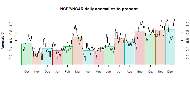
It was very warm in the Arctic, including over NE Siberia and Greenland, but once again cold over the Canadian Archipelago. Cold in Spain and the W Sahara. There was warmth From Mongolia through to N India and Thailand. Quite cool in the Middle East, from Egypt through to Iran.
The BoM ENSO Outlook is remains at Alert - but "...This indicates that if El Niño does develop, it is likely to be short-lived and weak." Still, it's already warm. .

This post is part of a series that has now run for some years. The NCEP/NCAR integrated average is posted daily here, along with monthly averages, including current month, and graph. When the last day of the month has data (usually about the 3rd) I write this post.
The TempLS mesh data is reported here, and the recent history of monthly readings is here. Unadjusted GHCN is normally used, but if you click the TempLS button there, it will show data with adjusted, and also with different integration methods. There is an interactive graph using 1981-2010 base period here which you can use to show different periods, or compare with other indices. There is a general guide to TempLS here.
The reporting cycle starts with a report of the daily reanalysis index on about the 4th of the month. The next post is this, the TempLS report, usually about the 8th. Then when the GISS result comes out, usually about the 15th, I discuss it and compare with TempLS. The TempLS graph uses a spherical harmonics to the TempLS mesh residuals; the residuals are displayed more directly using a triangular grid in a better resolved WebGL plot here.
A list of earlier monthly reports of each series in date order is here:


Nick, I get the same 0.582°C for March and 0.496°C for April for the 1994-2013 reference period from my independent analyses. I also have calculated the GMSTA from the same data set referenced to 1981-2010 and I get 0.683°C for March and 0.637°C for April, not quite as much of a drop and of course higher anomalies. For the unadjusted CFSR/CFSV2 I get 0.535°C for March and 0.432°C for April referenced to 1981-2010, which indicates a slightly larger drop. I'm sure if I had some different reference periods, the monthly drops would all be slightly different because of differences in the baselines, for both data sets.
ReplyDeleteThanks, Bryan, that looks like good concordance all around.
DeleteI once did a study, here, on the effect of different base periods on month to month differences. It can be significant. It came up in discussion on NCEP-NCAR; May temps in the 1994-2013 period were relatively cool, so this means that anomalies tend to rise going in to May, and then drop again. I think that is the main reason why a longish period like 30 years is recommended.
Nick, I just updated my NCEP-NCAR R1 baseline comparison post here to add a couple of graphs comparing the daily baseline change in Global Mean Surface Air Temperature (GMSAT) for some additional periods:
Delete1994-2013 minus 1981-2010 and 1994-2013 minus 1951-1980 graph here
1981-2010 minus 1951-1980 graph here
I find it interesting that in this data set, the largest temperature increases over time have been occurring in the August - October period, with the least increase in the December-January period. I'm not sure quite what to make of that.
It would be interesting to see the grid temperature differences in the baselines on a global map, but I don't have any easy way to do that.
Thanks, Bryan,
DeleteIt's interesting. There is as you say marked seasonal variation in the difference between bases. It seems consistent with the notion that times of NH winter are warming less rapidly than other times, at least around December.
This is a trivial thing to carp about, but in the NCEP/NCAR section of the data page, the table of daily measurements is updating, but the graph (to the right) is not -- it still ends with April, no data for May. At least when viewed in Firefox & Chrome on Windows 10 OS.
ReplyDeleteThanks, Ned
DeleteIt always helps to point out these problems; they won't get fixed until noticed. I hope this one is fixed now.
Thanks, that was quick. Looks good now.
Delete