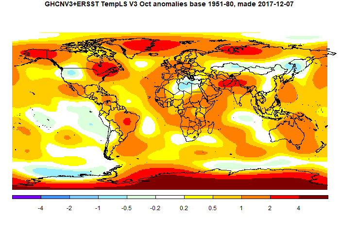
The overall pattern was similar to that in TempLS. Even warmer in Antarctica, cool in W US, and E Mediterranean, but the band of cool through to China is less continuous.
As usual here, I will compare the GISS and previous TempLS plots below the jump.
Here is GISS

And here is the TempLS spherical harmonics plot

This post is part of a series that has now run for six years. The TempLS mesh data is reported here, and the recent history of monthly readings is here. Unadjusted GHCN is normally used, but if you click the TempLS button there, it will show data with adjusted, and also with different integration methods. There is an interactive graph using 1981-2010 base period here which you can use to show different periods, or compare with other indices. There is a general guide to TempLS here.
The reporting cycle starts with a report of the daily reanalysis index on about the 4th of the month. The next post is this, the TempLS report, usually about the 8th. Then when the GISS result comes out, usually about the 15th, I discuss it and compare with TempLS. The TempLS graph uses a spherical harmonics to the TempLS mesh residuals; the residuals are displayed more directly using a triangular grid in a better resolved WebGL plot here.
The reporting cycle starts with a report of the daily reanalysis index on about the 4th of the month. The next post is this, the TempLS report, usually about the 8th. Then when the GISS result comes out, usually about the 15th, I discuss it and compare with TempLS. The TempLS graph uses a spherical harmonics to the TempLS mesh residuals; the residuals are displayed more directly using a triangular grid in a better resolved WebGL plot here.


Nick thanks for the update and your great analysis work. However, you're sometimes a bit sloppy on the language. In the CFSR data, the Oct 2015 GMST estimate was 15.0C whereas July and Aug 2015 were 16.5C. So October 2015 was nowhere near the "warmest month ever" at the time. You are conflating temperature anomaly and temperature as is all too common in the climate world. It was the highest global mean surface temperature *anomaly* estimate at the time. I bring this up because most people only see the GMSTA estimates and don't realize that GMST has a seasonal cycle of about 4C from highest in July to lowest in January. So only NH summer months realistically have a shot at the "warmest temperature ever" and likewise only NH winter months have a shot at "coldest month ever" ... depending on how far back you go on both counts.
ReplyDeleteBryan,
ReplyDeleteYes, hottest monthly anomaly would be more exact. I tend to drop "anomaly" because all the global average temperatures I talk about are anomalies. That isn't only because absolute averages are hard to calculate (big sample required). It's also because an anomaly average is more meaningful. In a warm anomaly month, everywhere in the world has, prima facie, an increased likelihood of feeling warmer than usual for that time. But if you say July is the warmest month, because it just is, that rings hollow to those few of us that huddle in the Southern Hemisphere.
I make this argument about NOAA's foolish custom of reporting the average temperature of ConUS as 56°F, or whatever. The only way a citizen can make sense of it is to subtract it from the ConUS average, and then add the difference to the local average. IOW, form an anomaly.
'So only NH summer months realistically have a shot at the "warmest temperature ever"'
I think that is a bug, not a feature.