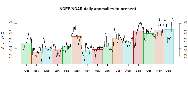
The main feature was a big cool band from the Sahara through Siberia to China. Also cold in the SE Pacific, with some La Nina like pattern. Mixed at the poles, but more warm than cold. Since Antarctica was cold last month, this suggests the warming will be reflected more strongly in GISS/TempLS rather than NOAA/HADCRUT.

First week of November is forecast to return to very warm temperatures; just in case anybody thinks the crash at the end of October means the 2nd coming of the paws has arrived. Still, NOV and DEC have to come in pretty warm to avoid dropping to the 3rd warmest year. October GISS>86 ℃?
ReplyDeleteInteresting developments in TLT land with a record warmest October reported by UAH, a record by quite a big distance. There's a UAH press release on WUWT suggesting that 'warmer than normal water in the equatorial eastern Pacific Ocean that peaked in June and July' are a major factor, which I can't understand. As far as I can tell that region wasn't warmer than normal in June and July.
ReplyDeleteThere was an anomalous spike peaking in March/April, which I guess could be a factor. I hadn't considered the lag could be that long before. But much of the TLT spike over the past few months seems to be in the SH Extratropics. Extratropical SH Eastern Pacific SSTs were also very warm early in the year, peaking in March.
Both regions saw big temperatures crashes in the subsequent months, so if they are major factor then TLT should drop quite dramatically over the next few months.
PaulS
ReplyDelete"As far as I can tell that region wasn't warmer than normal in June and July."
He might mean in the UAH map. I think there was some warmth in the SE Pacific, around 30-40S.
I can see what they're referring to now. They posted the graphic on their global temperature report. It's equatorial Central-East Pacific Upper Ocean (300m depth) heat anomalies.
DeleteCan't see how that works as an explanation though. The June/July anomalies are only about +0.25, which is nowhere near significantly above normal, and they're also not really warmer than earlier in 2017.
TLT seems to follow the RSS total water vapor dataset (over oceans only) with a lag of 2-3 months.
ReplyDeleteTLT should begin to drop next month...
The TLT broad layer temp doesn't reflect the energy content of the atmosphere very well. It overweighs warmth in thin air aloft, compared to that of denser air closer to the surface
Olof R: "TLT seems to follow the RSS total water vapor data set (over oceans only) with a lag of 2-3 months"
DeleteInteresting, it seems to be right for the 1998, 2010 and 2016 El Niños, but not for the Pinatubo cooling and some other cooling events. Anyway, can you suggest what the physics of this delay could be? (delayed vapor condensation?)
Your prediction for next month is maybe not so bold, the October RSS TLT has already peaked (only version 3.3 October data available so far)
RSS dropped a fraction from September but still record warm for October: http://images.remss.com/msu/msu_time_series.html
DeleteErik,
DeleteI think there is a delay because the latent heat (Water vapour) has to rise by convection, become sensible heat by condensation and transported poleward, etc.
RSS TLT has indeed peaked and dropped slightly, but RSS TTT rose in October. The TTT weighting profile is a little bit higher in the atmosphere, and actually more similar to the UAH v6 TLT profile than the classical TLT (as in UAH v5 and RSS).
However the difference between RSS TLT and TTT can also be explained by a big rise in temperature in the Antarctic region from Sep to Oct, an area that is cut off in the TLT dataset (goes only to 70S).
ReplyDeletejch1952, did you mispeak or am I misunderstanding something when you say "NOV and DEC have to come in pretty warm to avoid dropping to the 3rd warmest year"?
According to GISS, the second warmest year was 2015 with an anomalyy of 82 (0.82 deg. C). [source: https://data.giss.nasa.gov/gistemp/tabledata_v3/GLB.Ts+dSST.txt ]
Here is the GISS data for this year:
Year Jan Feb Mar Apr May Jun Jul Aug Sep Oct Nov Dec
2017 97 112 113 93 88 70 81 84 80 **** **** ****
For 2017 to tie 2015 for a second place ties finish, OCT - DEC anomalies will need to average 76. This is lower than all but one month this year. With OCT almost certainly being above 80, NOV and DEC can average a few points below 76 (like 71 if OCT really hits 86). An anomaly of 76 is pretty high historically, but there have only been 4 months lower than this in the last three years (since AUG 2014). So I will be very surprised if 2017 doesn't place second, it's going to take a big downturn in anomaly for the next two months for that to happen.
November so far is warmer than the October average, according to
Deletehttp://www.karstenhaustein.com/climate.php#forecast
so the probability for 2017 becoming second warmest on record is increasing..
Also, the odds of a 2017 La Niña starting in October are also melting away. - JCH
DeleteWhile a consolidated model for ENSO solidifies. Here are the two recent posts where the harmonic series approximation (conventional tidal analysis) for the ENSO forcing is reduced to a closed-form expression by applying Newtonian physics:
Deletehttp://contextearth.com/2017/10/27/reverse-engineering-the-moons-orbit-from-enso-behavior/
http://contextearth.com/2017/11/03/approximating-the-enso-forcing-potential/
This simplification was also applied to QBO.
I will present the findings at the AGU in New Orleans next month.