Most of North America was cool, except toward Alaska. far W Europe and most of Russia/Iran also cool. Central Europe was warm, elsewhere mixed. NE Pacific and Greenland were warm.

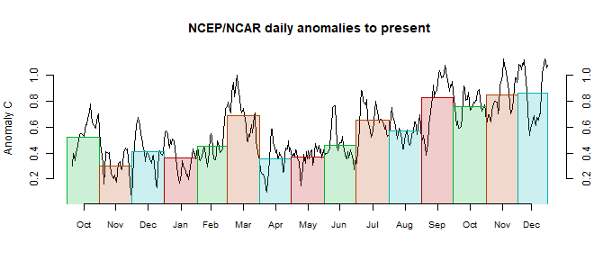
This post is part of a series that has now run for some years. The NCEP/NCAR integrated average is posted daily here, along with monthly averages, including current month, and graph. When the last day of the month has data (usually about the 3rd) I write this post.
The TempLS mesh data is reported here, and the recent history of monthly readings is here. Unadjusted GHCN is normally used, but if you click the TempLS button there, it will show data with adjusted, and also with different integration methods. There is an interactive graph using 1981-2010 base period here which you can use to show different periods, or compare with other indices. There is a general guide to TempLS here.
The reporting cycle starts with a report of the daily reanalysis index on about the 4th of the month. The next post is this, the TempLS report, usually about the 8th. Then when the GISS result comes out, usually about the 15th, I discuss it and compare with TempLS. The TempLS graph uses a spherical harmonics to the TempLS mesh residuals; the residuals are displayed more directly using a triangular grid in a better resolved WebGL plot here.
A list of earlier monthly reports of each series in date order is here:
Nick, I get the same monthly averages for October and November. Just for grins I calculated global surface air temperature anomalies for three different reference periods using the monthly CFSR/CDAS temperature output and compared 2019 October/November/Difference:
ReplyDelete1979-2000 0.546/0.544/-0.002
1981-2010 0.417/0.389/-0.028
1994-2013 0.282/0.211/-0.071
2011-2015 0.224/0.229/+0.005
Interesting how changing the reference period changes the Oct-Nov difference.
Bryan,
Delete"Interesting how changing the reference period changes the Oct-Nov difference."
Yes. I wrote here about the effect of anomaly base period on monthly changes. It reflects the fact that the 30-mnth base is itself a random variable. If 1961-90 happened to have warmish Mays and cool Junes, then in modern times anomalies to that base will tend to show an uptick going from May to June. But probably different if you use a 1981-2010 period.
Nick, thanks for the link. I had forgotten about that post, but I was certain you were familiar with this data feature. I mainly brought it up for new readers who might not be aware. I compared different baselines and their effects in the daily NCEP/NCAR Reanalysis1 data set back to 1948 in graphical form here for anyone who may be interested. If we had consistent data sources over the entire study period (unfortunately we don't), the changes over time would indicate trends in the seasonal patterns. But because of inconsistent data sources over time, I'm not confident that we can really make a good assessment in that regard.
DeleteIt also would be interesting to compare 100-year baselines, which I can imagine may become the norm for climatology hundreds of years from now. They should be more stable than 30-year baselines, but differences could reflect longer term ocean-atmosphere coupled effects over spans of centuries. I suspect that these long period ocean effects are probably responsible for major warming and cooling periods in the last several thousand years, including the historically categorized Minoan Warm Period, Roman Warm Period, Dark Ages (cool period), Medieval Warm Period, Little Ice Age (cool period), and perhaps now the Industrial Age Warm Period.
Warmest November on record in UAHv6 TLT.
ReplyDeleteWe now have a negative trend in November Antarctic sea ice (though way short of statistical signficance), the first appearance of any negative trend from 1979 in Antarctic sea ice since 2002, also in the November record. The statistically significant trend in Antarctic sea ice which was apparent a few years ago has now been completely eroded.
The change in Antarctic sea ice regime from 2015 to 2017 amplified the post-hiatus warming spike. On the order of a couple of tenths W/M2.
DeleteChubbs
Why is that?
DeleteLess sea ice ---> more sunlight absorbed
DeleteChubbs