There were few prominent patterns in the month. Cold in parts of S America, N Canada, and a large region of W Australia and adjacent ocean. Still warm in E Europe and far N Siberia, and NE USA. Contrasts in Antarctica.
BoM is still on El Niño Watch, meaning about a 50% chance, they say, but not yet happening.
Arctic Ice seems to have thawed slowly lately, with a likely September minimum about average for recent years.

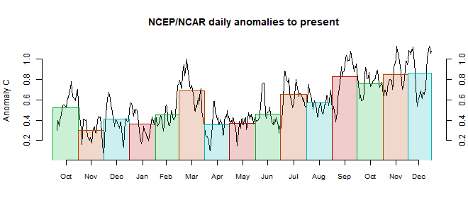
This post is part of a series that has now run for some years. The NCEP/NCAR integrated average is posted daily here, along with monthly averages, including current month, and graph. When the last day of the month has data (usually about the 3rd) I write this post.
The TempLS mesh data is reported here, and the recent history of monthly readings is here. Unadjusted GHCN is normally used, but if you click the TempLS button there, it will show data with adjusted, and also with different integration methods. There is an interactive graph using 1981-2010 base period here which you can use to show different periods, or compare with other indices. There is a general guide to TempLS here.
The reporting cycle starts with a report of the daily reanalysis index on about the 4th of the month. The next post is this, the TempLS report, usually about the 8th. Then when the GISS result comes out, usually about the 15th, I discuss it and compare with TempLS. The TempLS graph uses a spherical harmonics to the TempLS mesh residuals; the residuals are displayed more directly using a triangular grid in a better resolved WebGL plot here.
A list of earlier monthly reports of each series in date order is here:


The NCEP Climate Data Assimilation System (CDAS) preliminary monthly average global mean surface temperature for August 2018 based on daily CDAS averages of four runs per day was 16.367C, which is the lowest August average since August 2013 at 16.266C. The preliminary August 2018 CDAS global mean surface temperature anomaly referenced to 1981-2010 was 0.147C compared to 0.220C for July 2018 and was the lowest CDAS global mean surface temperature anomaly since 0.089C for April 2015.
ReplyDeleteThe CDAS centered running 365-day mean GMSTA has now dropped about 0.2 C from its El Nino related peak in early 2016, but is still about 0.2 C higher than it was in early 2014. Should be interesting to see what happens over the next year or two.
Thanks, Bryan.
DeleteThe CDAS drop then is 0.073°C, which is very similar. Yes, I think overall we're still considerably warmer than pre-2015.